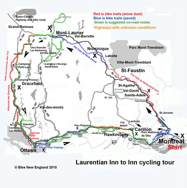
Tour of the Laurentians: A week-long bicycle tour in Quebec, camping version with inn to inn option
This
week-long tour is built around
Le P'Tit Train du Nord,
a 200 km (120 mile) bicycle path that originates northwest
of Montreal and continues to Mont Laurier in the
Laurentian
Mountains (referred to as the Laurentides in French) .
Our tour turns south to Ottawa, and then returns along the Ottawa River.
We chose Voyageurs Provincial Park near the Quebec-Ontario line to start
the tour, but you may use any location along the route to begin.
Evening stop locations shown are provincial campgrounds and/or inns
and campgrounds that are part of the "Bienvenue
Cyclistes" network. The total distance for this tour is approximately
600 km (370 miles) with an extra day option to Montreal, and a choice
of either one or two days from Ottawa back to the start location.
Check out also the
inn to inn version
of this tour.
Maps: Cue sheets and maps for all our tours (including this tour are available online and on disk . We recommend purchasing the 6th edition of Cycling in Quebec, a guide to Quebec's 4000 km Route Verte published by Velo Quebec. Video: View a reverse direction version of this tour from Ottawa in this You Tube video made by Alan Metcalf of his fall 2009 tour of the Laurentines .
Saturday, Start: Voyageur Provincial Park, Ontario
Voyageur Provincial Park is on the Ottawa River, about half way between Monteral and Ottawa and only a mile from the provincial border. From points south and east, you may find the best route to the park includes a drive through Montreal. (See below for Montreal start or extra day option). There are over 300 campsites designed primarily for tent camping, with comfort stations and showers. The park store sells groceries and sandwiches. A ferry service crosses the river from Point Fortune close by at Como, part of the town of Hudson. On the opposite side of the river from Voyageur is the town of Carillon, Quebec where Maison Desormeaux is part of the Bienvenue Cyclistes network, in case you prefer sleeping at a nice bed and breakfast to camping. Camping: Voyageur Provincial Park in Ottawa along river near Quebec line. Inn Option: Maison Desormeaux across the river in Carillon
Sunday, Day 1: to Sainte-Adele or Val David
In the morning, we take the ferry across the Ottawa River to Carillon There are several options here which will affect the distance for the day. You may head east on La Route Verte 1 , a paved shoulder on Quebec Rt. 344. It then joins the paved La Vagabonde trail, which runs 20 km from Parc National d'Oka.to Saint-Eustache, south of St. Jerome. To shorten the distance, we take local roads near the town of Lachute and ride along the North River, after crossing from Voyageur Park to Carillion, for approximately 100 km. In St-Jerome you will turn north on the stone dust section of La P'Tit Train du Nord. Camping is available in St-Jerome at Camping Lac La Fontaine), but we continue along Le P'Tit Train du Nord to Sainte-Adele or Val David. View the route on mapmyride.com . Camping : Camping Laurentian in Val-David, caters mostly to tent camping, and cyclists. Inns: Auberge du P'tit Train du Nord, 3065, rue Rolland, Sainte-Adèle, Québec . or Auberge La Bruyere Adele La Maison de Baviere in Sainte_Adele. cue sheet map
Monday Day 2 : St-Adele to Nominique
Continue today on Le P'Tit Train du Nord . At 50 km we reach Mont-Tremblant Village, which is the gateway to popular Parc national du Mont-Tremblant. The park has primitive campgrounds without modern facilities. Other Full service campgrounds include Camping Diable in the town of Mont-Tremblant_Village or Camping Chutes aux Iroquois in Labelle.) At 60 km in Labelle, Le P'tit Train du Nord becomes a paved trail all the way to Mont Laurier. We continue toward today's destination, L'annonciation or Nominique Camping: Camping Le Fou de Roi, and Camping Veronique in L'annonciation, djacent to the P'Tit Train du Nord. cue sheet map
Tuesday, Day 3: Nominique to Mont Laurier
Our tour continues on the paved section of Le P'tit Train du Nord to Mont Laurier, 80 km from L'Annonciation or 65 km if starting from Nominique. With a shorter ride today, you may choose to add one of their recommended cycling routes or take time to visit this popular town. Camping: Camping à la Clairière is 5 miles south of Mont-Laurier on Chemin Du Tour de Lac. Camping Parc Joan is 2 miles east of Mont Laurier just off Rt. 117. Inn option: La Maison de la Rive, 415 du Portage, Mont Laurier. (bienvenue cyclists). The Comfort Inn (bienvenue cyclists) (800) 345-6465, 700 Blvd. Paquette. Distances: L-Annonciation to Mont-Laurier is 45 miles. Lac-Nominique to Mont-Laurier is 34 miles. cue sheet map
Wednesday, Day 4: Mont Laurier to Gracefield
Today we leave Le P'Tit Train du Nord and start our ride
south toward Ottawa through the
Outaouais region. Continue west on the paved bike lane
on Rt. 117 (Route Transcanadiene) . Continue past the shortcut on Route 107 and turn south
in Grand-Remous on Rt. 105
to Maniwaki, the largest community in this otherwise
very rural section of Quebec. Both highways have a generous paved
shoulder and offer excellent cycling.
From Maniwaki you have a couple of options. You may continue
riding south on Rt. 105 to our destination,
Gracefield, (population 600). Or take the
Veloroute
des Draveurs, a 60 mile network of hilly gravel paths
and roads through the countryside from Maniwaki to Low, roughly parallel
to Rt. 105 and part of the
Trans-Canada
bike trail. At 18 km south of Maniwaki in Messines,
there is an option to take the Vallée-de-la-Gatineau Bike Trail
around Blue Sea lake south to Gracefield.
Cabin and Camping
: Le Bivouac d' La Ancien, Gracefield. Camping
Pioneer, Rt. 105 in Gracefield. Earlier camping 70
km from Mont Laurier:;
Camping Petit Lac, Messines,
QC , 70 km. (population 600). Inn option:
Auberge L'Entre-Deux-Mondes in Gracefield. We stayed at a
motel just south of town. Distances:
Today's ride is 95 km, when taking Rt. 105 or the Veloroute des Draveurs
, and a bit longer when opting for the bike trail aroundBlue Sea Lake.
cue sheet
map
Thursday, Day 5: Gracefield to Ottawa
Continue
south today on Rt. 105 or on the Veloroute des Draveurs, which ends
after 36 km in Low. In Wakefield you can get off the highway
for several miles where Rt. 105 turns right. After rejoining Rt.
105 in Chelsea, the shoulder is intermediate and the truck traffic is
rather heavy. Turn into the Park Gatineau after about 5 miles
for a much more pleasant ride the rest of the way to Ottawa. The
total distance from Gracefield to Ottawa is approximately 110 km (65
miles). Using this campground will make today's ride approximately
75 miles, and adds several miles to the next day's ride since you must
retrace to downtown Ottawa before continuing east. After crossing
the Portage bridge,we took the bike path along the river to downtown
Ottawa. Continue on Rideau St., where you will find many
inns to choose from , including
Gasthaus Switzerland
on the corner of Daly and Cumberland Sreets a few blocks after turning
onto Rideau. . Staying at a downtown inn offers
the opportunity to explore the city and the. The
Ottawa Municipal
Campground is 20 km (12 miles) west along the Ottawa River
Bikeway after crossing the Alexandra or Portage bridges.
While in Ottawa, don't miss riding on the
Rideau bike paths. a 16 mile loop on both sides of the canal.
. View all Ottawa bike routes at the
Capital Bikeway web page .
inn to inn cue sheet with map
camping route cue sheet and map
Gatineau Park bike map
Friday, Day 6: Ottawa to Parc Plaisance
Head out in the morning from Ottawa Municipal Campground . The Capitol Commission Parkway begins only a few blocks away and becomes the west side of the Ottawa River Parkway. In 12 miles you will reach downtown Ottawa. Take Rideau St. through Ottawa, cross the bridge over the Rideau River and take the Rideau River bike path to Sussex St. In a few blocks you will join the Ottawa River Parkway. A series of local bike paths continues even after the Parkway bike path ends, for a total of about 18 miles. Take Trim Road to Old Montreal Rd. (Rt. 30) and then about 5 miles to Cumberland. Take the ferry ($2 for bikes) across the Ottawa River to the Quebec side and continue east on Le Route Verte, highway 148, to Parc Plaisance , a nature preserve on two islands in the river. The campgrounds area is at Isle Petit Presque. This ride from Ottawa Municipal park to the campgrounds on Parc Plaisance is 57 miles, with scenic bike paths in the park . Route Verte alternative: You may cross the Alexandra bridge back into Quebec from Ottawa, taking Le Route Verte the entire way to Parc Plaisance. Camping: Campgrounds area at Isle Petit Presque in Parc Plaisance Inn Option: Auberge Des Relais Des Outarde, 202 Rue Principale 819-427-5195 cue sheet map
Saturday Day 7: from Parc Plaisance to Voyageur Park
Depart the Auberge or campground from Parc Plaisance and continue on La Route Verte 1 east. Some sections of Le Route Verte near Hawkesbury may have not been completed.. An option is to take the ferry from Fassette 10 miles east of Parc Plaisance across the river to Ottawa. Then take local route 24 along the south side of the river through Hawkesbury and on to Voyageurs park. If you started out the first night at the Auberge in Carillon across the river from Voyageurs, an option is to cross back over to Quebec on the bridge from Hawkesbury, taking la Route Verte 1 ( Chemin 2E to Rt. 344 ) Carillon. Options range from 41 - 50 miles depending on route taken. cue sheet map