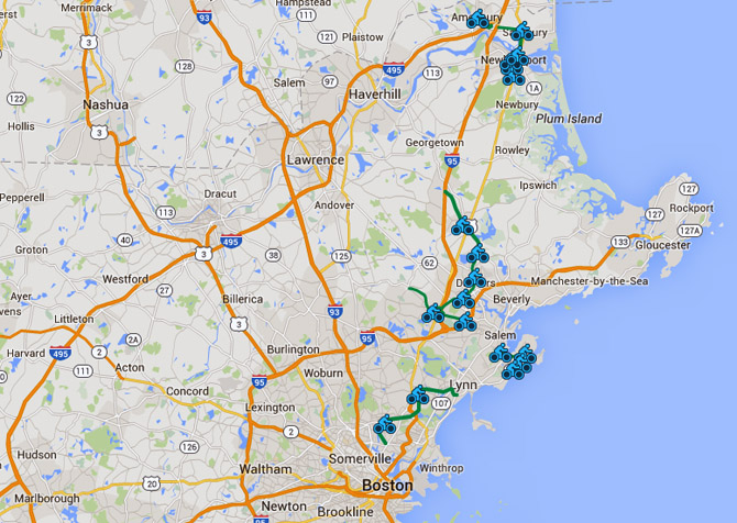
Border to Boston Rail Trail

Border to Boston rail trailBorder to Boston Rail Trail mapThe Border to Boston rail trail will be a 28-mile shared use trail from the New Hampshire border to Danvers in Essex County on Boston’s North Shore. The trail is being realized by the efforts of advocacy groups in each of the communities it passes through, overcoming the NIMBY attitude that organizers especially in Danvers faced. Aproximately 6 miles of the trail are on low-traffic roads between Boxford and Newburyport. In Newburyport the trail connects with the Coastal Trail network.

Salisbury to Newburyport  
Newburyport to Newbury
Newbury to Georgetown
Georgetown to Boxford
Boxford to Topsfield
Topsfield to Wenham
Wenham to Danvers
Danvers section
Peabody Rail Trail

Proposal for an Ipswich spur for the Border to Boston Rail Trail
Gordon Harris , Ipswich, MA

The fortunes of Ipswich Massachusetts since its founding in 1633 often have been subject to the changing nature of transportation. With a small harbor, we lost out to Newburyport, Essex and Gloucester as ships grew larger, leaving the town "off the map" and in an economic downturn. In 1804 the Ipswich Turnpike (Rt. 1A) and Newburyport Turnpike (Rt. 1) were built, followed by the Eastern Railroad in 1836. Soon the town boasted a thriving lace-making business and manufacturing began at the site of what is now Ebsco Publishing. The town's fortunes rebounded.

Today bicycles offer a new economic opportunity. I recently returned from cycling in Quebec on its visionary 4000 km "La Route Verte", which has brought an estimated $150 million in business to communities throughout the province. Closer to home, the Boston to Border Trail will follow the course of a former Boston and Maine rail line, connecting eight North Shore communities from Danvers to Newburyport. An on-road spur from Ipswich to Topsfield would benefit our popular coastal town. Topsfield recently completed a section of the trail and rebuilt a mile-long section of Ipswich Road with an adequate shoulder for cyclists. Hopefully they will extend the improvements to the Ipswich town line, where it would be relatively simple for Ipswich to widen Topsfield Road to include a 3 ft. cycling lane, replacing the inconsistent , occasionally non-existent shoulder and sunken drainage grates that force cyclists to ride in traffic. Cyclists could take this spur to Ipswich and continue on recently repaved Argilla Road to Crane Beach, a much safer ride now due to the advocacy of the Ipswich Cycling Advisory Committee and former selectpersons Elizabeth Kilcoyne and Ingrid Miles. Ipswich town manager Bob Markel supports the installation of a "rubber crossing" at the dangerous tracks near the commuter rail station, which would allow continuation of a Topsfield Road bike lane onto Depot Square, Hammat Street and newly repaved Central Street to avoid downtown traffic. The rail overpass on High Street is to be rebuilt, and MassHighway plans to rebuild Rt. 1A from there to Mile Lane, connecting to the existing generous shoulder which continues a dozen miles to Newburyport.

Changes take effort and money, not just wishful thinking. Despite our nearly 100 miles of roadways, former Ipswich DPW director Bob Gravino told me I was the first to contact him about cycling safety on Topsfield Road. Repaving roads costs over $100,000 per mile. The additional expense of a 3-foot paved shoulder benefits everyone, with automobile fatality rates 60-70 percent less than roads without paved shoulders. Grants are available from non-profit Bikes Belong and from the MA Department of Conservation and Recreation that could help build a recreational trail to Bradley Palmer State Park. I believe Ipswich can commit itself to the safety of cyclists and motorists for the 4.5 miles from the Topsfield town line to Lords Square , placing us "on the map" when the Boston to Border trail is completed.


More cycling routes in New England

This interactive listing of quality bike rides throughout New England gives our readers a direct link to fundraising rides, club rides and well vetted routes from Map My Ride (which does not have a graphic map index).  Contact Bike New England about adding your routes to this map. 

North Shore Cyclists rides Bike New England rides North Shore Cyclists rides North Shore Cyclists rides
North Shore Cyclists rides Cycling club and bike store rides North Shore Cyclists rides state cycling resources
North Shore Cyclists rides Green: Charles River Wheelmen rides North Shore Cyclists rides fundraising rides
North Shore Cyclists rides Map My Ride recommended rides  

Click anywhere on the map below to open a larger interactive Google cycling map with ride descriptions

bicycle map New England

Garmin Edge 705 GPS for bikes from Amazon.com


Email Bike New England  You can support our efforts when you purchase bikes, books, gear and cycling accessories by clicking on links on this site. 

Google

Search the Bike New England site

Bike New England, Ipswich MA Email Bike New England